 网站地图
网站地图

 下载:
下载:


-
“下击暴流”一词最早由FUJITA提出[1],气象上指能在近地面产生超过17.9 m/s辐散性大风的强下沉气流。FUJITA[2]和WAKIMOTO[3]根据下击暴流发生期间是否伴有强降水,将其分为干下击暴流和湿下击暴流,由于湿下击暴流与强降水密切相关,所以常伴有强的雷达反射率因子。下击暴流能产生极强的垂直风切变和水平风切变,触地后向上卷起,产生圆滚状的水平漩涡[4]。其产生的强下沉气流产生的强低空风切变会使飞机在短时间内失去空速,造成飞机意外失事[5]。而且下击暴流是雷暴强烈发展的产物,可由孤立的、反射率因子强度不强的对流风暴产生,也可由中尺度对流系统内嵌的强雷暴单体产生,所以其对航空运行安全的影响是复杂且多面的。
下击暴流因其时空尺度小、致灾性强、形成机理复杂,加之高时空分辨率探测仪器并未广泛推广,很难捕捉到其天气过程中的中小尺度信息,因此下击暴流天气预报预警是当前短时临近预报业务的难点。现今较为普遍的对下击暴流的检测仪器为多普勒雷达[6-8],但多普勒雷达在获取下沉气流信息,表征微下击暴流结构及近地层风场方面能力有限[9]。测风激光雷达(light detection and ranging, LiDAR)是新型的风场探测手段,可弥补传统测风手段在精细风场探测能力上的不足[10-11]。它能清晰地捕捉到下击暴流发生前垂直气流的演变、发生时显著的辐散速度对以及雷暴高压的反气旋风场特征[12],是具象化下击暴流的3维特征结构的有利工具,其在分析风切变成因[13-14]和低空急流中得到越来越广泛的应用[15]和预报人员的认可,而对下击暴流的表征研究并不常见,分析原因可能是因为下击暴流不常出现且尺度过小,移速快不易捕捉。
乌鲁木齐国际机场(国际民航组织代码是ZWWW)在2022-06-25发生了一次中γ尺度的湿下击暴流过程,湿下击暴流对处于干旱区的ZWWW极少出现,且难以捕捉。此次应用多种探测设备数据对该天气过程结构进行表征分析,有一定的科学研究价值和意义。西南技术物理研究所研制的FC-Ⅲ型激光测风雷达[16],是一部定位于低空风场3维探测和风切变监测预警的设备,于2021-09-09安装在25#跑道下滑台附近运行使用至今,对机场风切变对航班的影响分析已经起到了一定的作用[17]。本文中将对此次湿下击暴流的形成机理、生消过程的风场结构做分析,提高预报员对湿下击暴流的结构认知及识别和预警服务能力。
-
本文中使用的资料包括:(a)美国大气环境中心提供的全球再分析(final operation global analysis,FNL)资料,其时间分辨率为6 h,水平分辨率为1°×1°;(b)新疆区域自动站逐时观测资料;(c)乌鲁木齐机场自动气象观测系统(automatic weather observing system,AWOS)实测资料、激光雷达资料、多普勒雷达资料、微波辐射计资料。
-
乌鲁木齐机场于2022-06-25出现了中γ尺度的湿下击暴流天气。具体表现为:17:18中阵雨;17:21—17:26中雷雨伴13 m/s西北阵风,后续弱雷雨伴10 m/s西北风;17:36—18:20雷暴,过程降水量为1.1 mm。乌鲁木齐机场在62 min内经历了大风、西北风-东南风-西北风的转换、强降水等天气,在跑道南侧出现了由下击暴流引发的25 m/s的雷暴大风。天气持续时间短、起止突然,各天气要素在短时间内变化剧烈。
下击暴流前后ZWWW跑道两端风场变化如图 1a所示。下击暴流前期为偏西-西北风,平均风4 m/s~ 6 m/s,跑道两端风向风速基本一致。25#跑道从17:18开始风速加大,突增的时间点为17:19—17:21,增幅5 m/s;17:21—17:22 1 min时间风速减小7 m/s;17:22—17:23,风向转换180°,25#跑道风向西北转东南,风场矢量差达16 m/s,而后经过4 min的振荡,于17:40后维持在2 m/s~4 m/s西-西北风,由此可见近地面风场变化显著。结合多普勒雷达和测风激光雷达数据分析(详见下文)可知25#段更接近雷暴高压的主体,风场变化明显且剧烈。07#段在高压后部,整体相对平稳,雷暴高压过后,后续受入侵冷空气影响持续6 m/s~10 m/s西北风,风速反超25#。
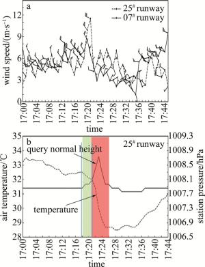
图 1 ZWWW下击暴流前后AWOS气象要素分布
Figure 1. Distribution of AWOS meteorological elements during the downburst at ZWWW
分析25#跑道温压场的变化(如图 1b所示)可知,25日气温于17:01达到最高33.5 ℃,而后17:06单体在ZWWW北侧激发并处于发展阶段,机场持续降温,风场出现脉冲式振荡(见图 1a),此时对应的气压场并无明显变化。可见温度场最为敏感其次为风场,气压场相对迟缓;17:18机场已经出现中阵雨,降水的拖曳作用使得冷空气下沉,机场气温以0.5 ℃/min的速率降低,气压以0.13 hPa/min的速率增加(绿框所示)。雷暴高压形成后且途经ZWWW 25#跑道段时刻,引发机场中雷雨(红框所示),期间减温率达至1 ℃/min,且降温持续至17:33后显著回温;17:18—17:26强降水期间,增减压率几乎对称变化,尤其是17:21—17:25中雷雨期间气压呈过山车式变化,绝对值为0.3 hPa/min。侧面说明ZWWW受小尺度雷暴高压的影响,雷暴高压的移进和移出导致ZWWW的气压场变化增减显著,同时说明雷暴高压移动迅速。增压(17:23)相对于强降水(17:18)的滞后现象说明了湿下击暴流的强降水的发生对下击暴流有触发和预警作用。
基于跑道两端风场及25#跑道端的变化进一步佐证了此次中γ下击暴流尺度小,强度强、移速快,也佐证了雷暴高压的存在,初步判断其为移动型下击暴流。
-
2022-06-25T08:00时500 hPa(见图 2a)形势显示,巴尔喀什湖暖脊向北发展,脊前西北气流下有冷空气输送且有风速的复合和冷空的堆积;20:00时(图略)脊区经向度减弱明显,对于ZWWW来说冷空气的堆积和渗透结束。同时,850 hPa北疆盆地到沿天山一带有一支南北向的切变线,乌鲁木齐机场处于切变线南端,存在明显的风向风速辐合,17:00时(见图 2b)也显示ZWWW上游有辐合风场,所以在周边高温高湿的背景下,边界层风场切变,有助于静力不稳定层结发展和不稳定能量的释放。
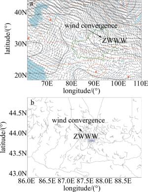
图 2 2022-06-25天气形势场及地面气象要素分布
Figure 2. Weather situation and surface meteorological element field automatic weather station at 2022-06-25
-
17:06(图略)雷达观测到ZWWW西北侧5 km附近有一孤立单体回波生成,此时反射率因子均在30 dBZ以下,17:12时(见图 3a),最大反射率因子就达40 dBZ~45 dBZ,沿a-b方向做最强回波剖面(下同),可见,最强反射率因子在2 km以上,对流单体处于发展阶段;17:19时(见图 3b),上述孤立单体已进入成熟阶段,最大反射率因子达60 dBZ,回波顶高达10 km,属于中γ尺度的对流单体,回波中心开始下降,引发中阵雨,最强回波位于0.5 km~1.5 km之间,并未接地,冷空气开始在地面堆积,气压加强;17:25时(见图 3c)对流单体发展至强盛阶段,最大反射率因子维持在55 dBZ~60 dBZ且高度下降,雷暴高压发展成熟,水平尺度小于2 km,强回波接地及雷暴高压的成熟也说明雷暴单体开始进入衰亡阶段。另一方面,在17:25时0.5°、1.5°仰角回波反射率因子强度图上(图略),探测到钩状回波,回波入流缺口位于单体东南侧,结合激光雷达,显示该处有明显的东南风入流,反射率因子在垂直方向上也向入流一侧倾斜;17:31时(图略),单体回波继续东南移动且迅速减弱,整个生命史历时19 min。
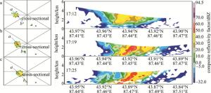
图 3 下击暴流过程中雷达组合反射率因子及对应时刻强回波剖面
Figure 3. Composite reflectivity factor during downburst and the vertical cross-sections of reflectivity factor through the strong echo cells
-
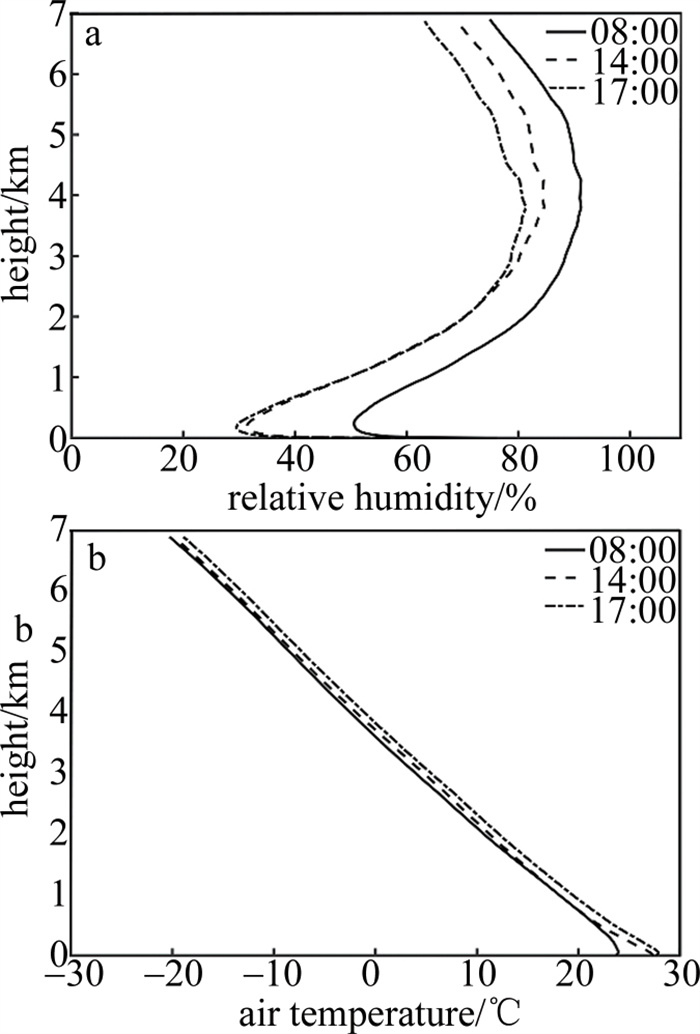
强的不稳定能量是造成此次强天气过程的关键。2022-06-25T08:00时,ZWWW上空1 km~7 km相对湿度超过70%,湿层深厚(见图 4a);14时由于日变化作用,湿层抬升至2 km~7 km且整体湿度有所下降;17时,2.5 km以上的相对湿度进一步减少,但2.5 km以下基本无变化,说明边界层内有水汽补充,边界层有不稳定扰动。相对应的边界层1 km以下气温发生明显变化(见图 4b),08:00—17:00时,2 m气温升高9 ℃,而对流层内气温无明显变化,“上冷下暖”的配置有利于对流不稳定层结增长;16时,地面至1 km之间产生了一个近似干绝热层,环境温度递减率9.2 ℃/km (干绝热递减率为9.8 ℃/km),大的环境温度递减率有利于气块在下降过程中保持向下的加速度。
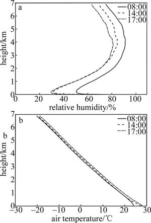
图 4 2022-06-25 ZWWW微波辐射计反演物理量参数
Figure 4. Charts of ZWWW microwave radiometer inverts physical quantity parameters at 2022-06-25
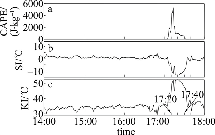
从ZWWW各热力不稳定参数(如图 5所示)来看,2022-06-25T17:00时前乌鲁木齐机场对流有效位能(convective available potential energy,CAPE)为0 J/kg,沙氏指数(Saffir-Simpson index,SI)在1 ℃~4 ℃,K指数(K index,KI)在30 ℃~35 ℃,中低层湿度条件较好,但不存在明显的不稳定层结,17:05左右不稳定能量迅速积累,CAPE增大至409.6 J/kg,SI减小至-2.2 ℃,KI增加至39.8 ℃。强降水发生前6 min对流有效位能达到最大(见图 5a),CAPE值为5291.3 J/kg,极端高的CAPE值可使气块快速通过暖云层,减少形成降雨的时间,随后不稳定能量迅速释放,强降水期间仍然维持在800 J/kg~900 J/kg,CAPE降至0 J/kg后,降水随之结束。SI(见图 5b)峰值出现在强降水期间,SI值为-13.1 ℃~-13.5 ℃,随后SI迅速降低,降水也随之减弱,SI指数降至-2.0 ℃后,雷雨天气结束。KI(见图 5c)在CAPE达到峰值的同时出现第1个峰值(52.1 ℃),中低层水汽在对流有效位能快速释放所产生的强上升运动作用下迅速凝结,并在强降水期间出现第2个峰值(52.3 ℃),KI下降到40 ℃以下时,雷雨天气逐渐结束。

图 5 2022-06-25T14:00—18:00时ZWWW微波辐射计反演热力不稳定参数
Figure 5. Charts of ZWWW microwave radiometer inverts thermal instability parameter variation at 2022-06-25T14:00—18:00
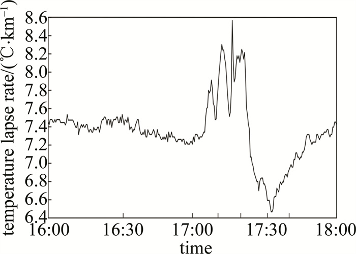
气块下降过程中负浮力能否维持是强下沉气流维持和加强的关键,0 ℃层以下的温度递减率在一定程度上能反映负浮力的大小。根据ZWWW 0 ℃层以下温度递减率(如图 6所示)可知,在强天气发生前的0 ℃层以下温度递减率就维持在一个比较高的水平(7.2 ℃/km~7.6 ℃/km),大于标准大气对流层的平均温度递减率6 ℃/km。17:05左右0 ℃层以下温度递减率陡增,至17:10达到8 ℃/km,强降水期间0 ℃层以下温度递减率为8.1 ℃/km~8.2 ℃/km,明显高于对流层中、下层湿绝热递减率。下沉气流在下降过程中的升温速度低于环境的升温速度,因此气块下降过程的负浮力能够维持,有利于强下沉气流的出现。强降水结束后,地面气温迅速降低,0 ℃层以下温度递减率也随之降低。
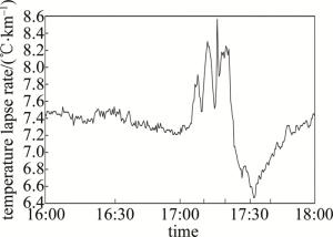
图 6 2022-06-25T16:00—18:00时ZWWW微波辐射计反演0 ℃层以下温度递减率
Figure 6. Charts of ZWWW microwave radiometer inverts temperature lapse rate below 0 ℃ layer at 2022-06-25T16:00—18:00
-
基于上面的分析,可知整个湿下击暴流发生的时间、强对流单体的发展情况及雷暴高压(强回波下降)的形成过程,但是对于下击暴流具体的外流大风区、外流边界、雷暴高压的具体位置、下沉气流的高度及强度等要素无法表征。测风激光雷达的风场数据恰恰可以弥补上述数据的不足,从而对该次下击暴流风场结构的表征更加完善。
-
由风廓线探测的风场可知,16:50以前1.5 km以上和近地面多为西北风,中间层风场较乱,说明环境背景并不稳定有乱流和湍流的存在;16:50时(见图 7a)风场变化较为统一,1.5 km以下风向随高度顺转,底层暖平流,1.5 km~3 km逆转,表明该区域有冷平流侵入;至17:07时冷平流势力增强,300 m~1400 m为下沉气流,对应了单体发展的时刻,动量下传地面风加大。冷空气下沉压缩近地面暖空气,底层干暖,中层冷湿,进一步加强的温度递减率,为不稳定能量的积累和爆发提供了有利条件;17:16时强对流发展成熟并入侵ZWWW,500 m高度风速增至11 m /s,整层风向转为一致的西北风,风速比上个时次增强2 m/s~5 m/s,且配合明显的上升运动(见图 7b),预示着雷暴单体还在进一步的发展;值得注意的是,17:16—17:24时,1.5 km以下风场有反气旋性旋转(如图 7a中黑圈所示),预示300 m以下风向由西北转为西南突变,最大风位于1536 m高度,风速达16 m/s且伴随显著的4.78 m/s下沉气流(见图 7b),下沉运动由该高度开始发动。上升气流于1649 m高度开始,最大值为4.16 m/s,两者矢量差为8.94 m/s,达风切变标准。1536 m~1000 m之间的下沉气流速度最大,表明下沉气流在持续下冲并加速;由于雷暴单体过境伴随强降水对激光的衰减作用,1536 m~1649 m之间风数据缺失,侧面反映出雷暴单体内部运动剧烈。17:24—17:33时,500 m以下、1 km~1.6 km,2.5 km以上风场由西南转为偏西气流,可以看出,强对流单体中层存在气旋性风场(如图 7a中红圈所示),至17:33时转为上升气流。
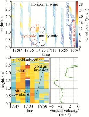
图 7 2022-06-25T16:47—17:54时测风激光雷达风廓线探测模式
Figure 7. Doppler beam swinging images measured by lidar at 2022-06-25T16:47—17:54
-
雷暴高压形成过程、夹卷大风区及外流边界在平面位置显示模式(plan position indicator,PPI)和机场跑道方位的距离高度显示模式(range height indicator,RHI)图上有更显著的表现(见图 8)。17:02和17:07的6°和3° PPI产品中(图略)在ZWWW 330°方向4 km左右的位置有东北-西北气流的辐合,配合垂直速度图可知,300 m以下辐合上升,强对流单体处于发展阶段,与前面的结论一致,且3° PPI图中辐合区离雷达更近,表明辐合区后倾,雷暴带来的冷空气底层进入快。
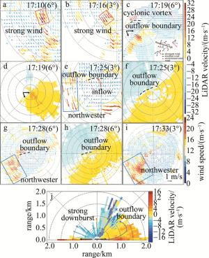
图 8 下击暴流过程中PPI/RHI模式产品
Figure 8. PPI/RHI mode products through the downburst
17:10时的6° PPI(见图 8a)出现小股强风渗透,雷达240°~270°方向,1.5 km~2 km处(红框)偏北风15 m/s~18 m/s;17:16时的3° PPI(见图 8b)雷达210°~230°方向1.5 km~2.5 km(红框)距离处出现10 m/s~15 m/s西北风,说明大风下冲且对流单体在移动;直到17:19时的6° PPI(见图 8c),激光雷达监测到了发展中的雷暴高压、下击暴流引发的大风,最大风速为23.2 m/s(达到下击暴流标准)以及外流边界,凸显了测风激光雷达在表征风场结构中的优势。具体原因为:对比PPI图可知,雷达270°方向600 m~1000 m处风场由一致的西北风转为西北和西南的转换,呈“八字胡”式的风场转换,该种风场的变化恰为西北环境风下的雷暴高压形成时周边风场的转换形式。且在雷达200°~230°方向,距离形成中的雷暴高压东南侧500 m,西北风增幅15 m/s~17m/s;另外在雷暴高压东北侧700 m处有偏东及偏西风的辐合带,即外流边界(黑色虚线处),且在径向速度中表现更明显(见图 8d),配合紧跟其后的RHI产品(见图 8j)可知,距离雷达以西500 m近地面风场辐散显著,佐证了雷暴高压的形成过程及位置,距离高压1 km左右位置外流大风最大值为10 m/s~15 m/s。雷达45°以西南1.5 km均为负径向速度且速度较大,45°附近1 km左右正负径向速度交替,45°以东北为正径向速度且数值随高度降低,很好地表征了下沉气流伴有的大风,外流边界及边界的大风夹卷,夹卷高度为500 m~1000 m左右。
另外需要关注的是,在雷达西部800 m~1000 m处(外流边界以北),出现弱径向速度辐合式气旋性涡旋(见图 8c红圈处),高度80 m~100 m左右。研究表明,雷暴单体中常有小涡旋的存在,并伴随有龙卷、强风等天气的发生[18]。根据激光雷达的监测,该小涡旋引发了24 m/s的大风,17:19时发生,17:28时结束,整个过程持续9 min。虽然该气旋性涡旋并未达到中气旋的标准,但其结构和作用与中气旋类似,是强对流天气发生的明显信号和预警指标[19]。
至17:25时3° PPI的径向速度图(见图 8e~图 8f),雷暴高压对应的外流边界显示更为明显,结合水平场可见,雷暴高压和对应的辐散气流都更加明显,雷暴高压移至雷达180°方向500 m~1500 m处,外流边界位于雷暴高压西北侧500 m处,为西北和东南风的辐合区,且该东南气流佐证了钩状回波的风暴入流,进一步完善了雷暴单体结构的完整性;雷暴大风区移至雷达140°~170°方向、2 km~3 km处,距离雷暴高压1.2 km,风速集中在16 m/s~25 m/s,最大值25.54 m/s,大风区范围变大,风速变强。强降水引起激光衰减导致17:28时的6° PPI(见图 8g~图 8h)东南侧风场数据缺失严重,但雷暴高压和外流边界的位置依然明显,根据相邻两个时刻的雷暴高压的位置,可以大概估算出8.5 min前进1.5 km,速率为10.6 km/h。雷暴高压主体有1 km左右,修订了第3.2节中对雷暴高压判定的结果。且通过3° PPI径向图和6° PPI径向图中风场正负包围的范围可见,下沉气流上窄下宽,倒漏斗状,符合雷暴下沉气流引发的辐散大风是湿下击暴流的结构特点。
值得注意的是,在图 8e、图 8g和图 8h中雷暴高压的西北侧,几乎是紧跟着雷暴高压出现了4 km×6 km大小的西北大风区,且具有脉冲特点,对雷暴高压大风的西侧外流产生了影响和阻挡,所以在雷暴高压的西侧100 m~2000 m处出现了偏东风与偏北风的切变。对07#下滑道产生非常大的影响,出现了中度风切变告警,和该区域内的强西北大风。由此可以推断雷暴高压后部有小尺度冷空气进入,也可以说此次强对流是冷空气前沿的激发。
17: 33前后,3° PPI显示雷暴高压四周辐散环流维持(见图 8i),后续冷空气带来的脉动西北风挤压雷暴高压向西的外流气流,顺时针旋转特征明显减弱,且高压中心的风速也有所减小,低于下击暴流标准,下击暴流天气基本结束。
由此可见,测风激光雷达不仅能观测到雷暴高压的中心位置和顺时针旋转特征,还能确定高压区域大小和强度变化,更重要的是能实时动态跟踪风切变区,对飞行安全提供精细预警。风廓线扫描模式能很好地捕捉强下沉气流的时间和强度。
-
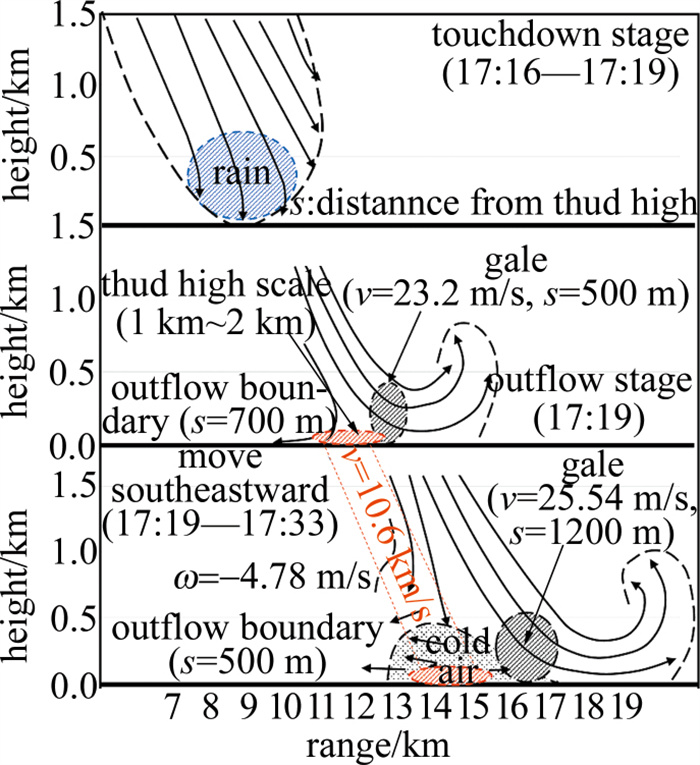
结合前面分析,此次雷暴单体引发下击暴流的结构图如图 9所示。对流单体尺度在7 km~10 km。强对流单体发展过程为:17:12时发展,到17:19/17:25时成熟(引发下击暴流),17:31时消亡,且在17:25时反射率因子强度图上监测到钩状回波;下击暴流发生前有冷平流下压,进一步加强的温度递减率,为不稳定能量的积累和爆发提供了有利条件。17:16—17:24时,1.5 km以下风场有反气旋性旋转,预示着下沉气流的产生;至17:24时,300 m以下风向突变,由西北转为西南。1536 m~1000 m的下沉气流速度最大,下沉气流在持续下传并加速,且在1536 m~1649 m高度处为上升下沉气流的分界线,垂直速度矢量差为9 m/s。基于PPI和RHI产品的分析可知,雷暴高压形成于17:19时、雷达270°方向、600 m~1000 m,下击暴流引发的大风区位于雷暴高压东南侧500 m,外流边界位于雷暴高压东北侧700 m;17:25时雷暴高压和对应的辐散气流都更加明显,雷暴高压以10.6 km/h向东南方向移动,大风区延申向前,位于雷暴高压东南侧1.2 km处,且范围变大,风速变强,大风夹卷高度在500 m~1000 m左右。外流边界里雷暴高压更近些,位于高压西北侧500 m。下沉气流上窄下宽,倒漏斗状,符合雷暴下沉气流引发的辐散大风即湿下击暴流的结构特点。
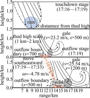
图 9 2022-06-25中γ尺度移动型湿下击暴流模型
Figure 9. Medium-scale mobile wet downdraft model at γ scale at 2022-06-25
-
本文中讨论了发生在ZWWW的一次罕见湿下击暴流过程,结合多源数据的应用,对突发在跑道上的下击暴流的生消过程及风场结构进行了较为细致的分析,佐证了测风激光雷达资料在中小尺度强对流天气结构分析中的优势作用。
(a) 雷暴单体的生消移动及下击暴流的产生导致ZWWW气象要素的剧烈变化,25#跑道更接近雷暴单体,气象要素变化强于07#跑道,雷暴高压形成后途经跑道带来温度骤降,气压陡升,风向转换频繁和局部大风等要素变化,辅助说明雷暴高压移动迅速。且空中局部无数据(强降水对激光衰减造成)对下击暴流的发生有触发和预警作用。
(b) 多普勒雷达资料直观地反映了机场上空对流单体发展情况及个体大小,明确了强对流单体发展各个阶段的时间。激光雷达风廓线数据清晰地反映出下击暴流前后时段风场的转换及垂直气流的变化:下击暴流发生前有冷平流下压,进一步加强的温度递减率为不稳定能量的积累和爆发提供了有利条件。
(c) 微波辐射计资料分析表明,强的不稳定能量是造成此次强天气过程的关键。“上干下湿”的湿度场,大的环境温度递减率,使得在强降水发生前6 min,不稳定能量积攒到最大,随后能量迅速释放,出现短时强降水,气块加速下降,强下沉气流出现,触发湿下击暴流。
(d) 激光雷达数据分析清晰展现了这次下击暴流的风场结构,风廓线数据中监测到强下冲气流前机场上空的反气旋性旋转,明确了下冲气流启动高度;PPI及RHI数据详细表征了雷暴高压形成过程、移动速度、夹卷大风区与雷暴高压的位置关系及外流边界的延申特点,下击暴流的上窄下宽,倒漏斗状结构也有所反映。
测风激光雷达对孤立雷暴引发湿下击暴流的结构分析
Structural analysis of wet downburst triggered by isolated thunderstorms based on wind LiDAR
-
摘要: 为了揭示中γ尺度孤立单体雷暴引发的下击暴流的风场结构及成因,采用多源数据结合的方法着重分析了激光雷达资料,对2022-06-25发生在乌鲁木齐机场跑道入口端的一次湿下击暴流进行了结构场剖析,取得了能够表征下击暴流发生发展过程的数据。结果表明,本次过程发生在西北气流控制且有明显风场辐合和冷空气堆积的背景下,中低层切变线和地面中尺度辐合线是此次过程的触发机制;两个气象雷达体扫呈现了孤立雷暴的初生-发展-成熟阶段,及回波中心下降接地引发湿下击暴流的过程;强的不稳定能量是造成此次强天气过程的关键;强降水发生前6 min不稳定能量积攒至最强,随后能量迅速释放,强下沉气伴短时强降水,触发了湿下击暴流;测风激光雷达可观测到雷暴高压始发的中心位置和反气旋特征、大风区和外流边界,明确了高压区域大小和强度变化,对强下沉气流爆发的时间和强度指征明显。这些结果为研究雷暴单体引发下击暴流的结构提供了有力支持,提高了民航精细化服务的能力。Abstract: In order to reveal the wind field structure and cause of the downdraft generated by a mesoscale isolated thunderstorm in the central γ region, a method of combining multi-source data was adopted, with a focus on the analysis of the light detection and ranging (LiDAR). A structural field analysis of a wet downdraft that occurred at the entrance end of the runway at Urumqi Airport on 2022-06-25 was carried out, and data that can characterize the development process of the downdraft were obtained. The results showe that under the background of northwest airflow convergence and cold air accumulation, the mid-low level shear line and the ground mesoscale convergence line were the triggering mechanisms for this process. Two Doppler radar volume scans present the process of the initial development and mature stages of the isolated thunderstorm, with the the process of moist downbursts caused by echo center descending and strong echoes reaching the ground. Strong unstable energy was the key factor causing this severe weather process. The unstable energy accumulated to its maximum 6 min before the occurrence of heavy precipitation, and then rapidly released, accompanied by short-term intense precipitation and triggered the wet downdraf. The center position and anticyclonic characteristics of the thunderstorm high pressure initiation were observed through the wind LiDAR, the area of strong winds and the outer boundary of outflow were then estimated, the size and intensity changes of the high-pressure area were clarified. It provided clear indications for the timing and intensity of the outbreak of the downdraft, and provided strong support for the analysis of the structure of thunderstorm-induced downdrafts, as well as fine warning for flight safety.
-
Key words:
- laser technique /
- wet downburst /
- wind LiDAR /
- wind field structure characteristics /
- flight safety
-
图 1 ZWWW下击暴流前后AWOS气象要素分布
Figure 1. Distribution of AWOS meteorological elements during the downburst at ZWWW
图 2 2022-06-25天气形势场及地面气象要素分布
a—08:00时500 hPa位势高度及风温场形势场b—17:00时地面风场
Figure 2. Weather situation and surface meteorological element field automatic weather station at 2022-06-25
a—potential height, wind field and temperature field with 500 hPa at 08: 00 b—surface wind field at 17: 00
图 3 下击暴流过程中雷达组合反射率因子及对应时刻强回波剖面
Figure 3. Composite reflectivity factor during downburst and the vertical cross-sections of reflectivity factor through the strong echo cells
图 4 2022-06-25 ZWWW微波辐射计反演物理量参数
Figure 4. Charts of ZWWW microwave radiometer inverts physical quantity parameters at 2022-06-25
图 5 2022-06-25T14:00—18:00时ZWWW微波辐射计反演热力不稳定参数
Figure 5. Charts of ZWWW microwave radiometer inverts thermal instability parameter variation at 2022-06-25T14:00—18:00
图 6 2022-06-25T16:00—18:00时ZWWW微波辐射计反演0 ℃层以下温度递减率
Figure 6. Charts of ZWWW microwave radiometer inverts temperature lapse rate below 0 ℃ layer at 2022-06-25T16:00—18:00
图 7 2022-06-25T16:47—17:54时测风激光雷达风廓线探测模式
Figure 7. Doppler beam swinging images measured by lidar at 2022-06-25T16:47—17:54
图 8 下击暴流过程中PPI/RHI模式产品
a~c, e, g, i—水平风场d, f, h—径向速度j—RHI模式的径向速度
Figure 8. PPI/RHI mode products through the downburst
a~c, e, g, i—horizontal wind d, f, h—radial vector j—radial velocity of RHI mode
-
[1] FUJITA T T, BYERS H R. Spearhead echo and downburst in the crash of an airliner[J]. Monthly Weather Review, 1977, 105(2): 129-146. doi: 10.1175/1520-0493(1977)105<0129:SEADIT>2.0.CO;2 [2] FUJITA T T. Five scales of airflow associated with a series of downbursts on 16 July 1980[J]. Monthly Weather Review, 2009, 109(7): 1438-1456. [3] WAKIMOTO R M. Forecasting dry microburst activity over the high plains[J]. Monthly Weather Review, 1985, 113(7): 1131-1143. doi: 10.1175/1520-0493(1985)113<1131:FDMAOT>2.0.CO;2 [4] FUJITA T T. The downburst (report of projects NIMROD and JAWS)[R]. Chicago, USA: University of Chicago, 1985: 122. [5] 孙凌峰, 郭学良, 孙立潭, 等. 武汉"6·22"空难下击暴流的三维数值模拟研究[J]. 大气科学, 2003, 27(6): 1077-1092. doi: 10.3878/j.issn.1006-9895.2003.06.11 SUN L F, GUO X L, SUN L, et al. A numerical study of the airplane disaster-producing microburst on 22 June 2000 in Wuhan[J]. Ch-inese Journal of Atmospheric Sciences, 2003, 27(6): 1077-1092 (in Chinese). doi: 10.3878/j.issn.1006-9895.2003.06.11 [6] ROBERTS R D, WILSON J W. A proposed microburst nowcasting procedure using single-Doppler radar[J]. Journal of Applied Meteorology, 1989, 28(4): 285-303. doi: 10.1175/1520-0450(1989)028<0285:APMNPU>2.0.CO;2 [7] EILTS M D, JOHNSON J T, MITCHELL E D, et al. Damaging downburst prediction and detection algorithm for the WSDR-88D[C]// 18th Conference on Severe Local Storms. San Francisco, USA: Bulletin of the American Meteorological Society, 1996: 541-545. [8] 吴芳芳, 王慧, 韦莹莹, 等. 一次强雷暴阵风锋和下击暴流的多普勒雷达特征[J]. 气象, 2009, 35(1): 55-64. WU F F, WANG H, WEI Y Y, et al. Analysis of a strong gust front and downburst with Doppler weather radar data[J]. Meteorological Monthly, 2009, 35(1): 55-64 (in Chinese). [9] 王艳春, 尉英华, 张楠, 等. 2017年夏季天津一次下击暴流事件的成因初探[J]. 暴雨灾害, 2022, 41(5): 556-563. WANG Y Ch, WEI Y H, ZHANG N, et al. Preliminary study on the causes of a downburst event in Tianjin in the summer of 2017[J]. Torrential Rain and Disasters, 2022, 41(5): 556-563 (in Ch-inese). [10] 王青梅, 郭利乐. 测风激光雷达在机场低空风切变探测中的应用[J]. 激光与红外, 2012, 42(12): 1324-1328. doi: 10.3969/j.issn.1001-5078.2012.12.002 WANG Q M, GUO L L. Development of lidar in detection of low altitude wind shear[J]. Laser and Infrared, 2012, 42(12): 1324-1328 (in Chinese). doi: 10.3969/j.issn.1001-5078.2012.12.002 [11] THOBOIS L, CARIOU J P, GULTEPE I. Review of lidar-based applications for aviation weather[J]. Pure and Applied Geophysics, 2019, 176(5): 1959-1976. doi: 10.1007/s00024-018-2058-8 [12] 张涛, 黎倩, 郑佳锋, 等. 测风激光雷达研究微下击暴流引发的低空风切变[J]. 激光技术, 2020, 44(5): 563-569. ZHANG T, LI Q, ZHENG J F, et al. A study on low-level wind shear caused by microburst using lidar and other data[J]. Laser Technology, 2020, 44(5): 563-569(in Chinese). [13] 黄轩, 郑佳锋, 张杰, 等. 西宁机场一次低空风切变的结构和特征研究[J]. 激光技术, 2022, 46(2): 206-212. HUANG X, ZHENG J F, ZHANG J, et al. Study on the structure and characteristic of a low-level wind shear process that happened over Xining Airport[J]. Laser Technology, 2022, 46(2): 206-212 (in Chinese). [14] 梁希豪, 杨寅, 冯亮, 等. 基于测风激光雷达银川机场动量下传大风特征研究[J]. 激光技术, 2023, 47(3): 432- 438. LIANG X H, YANG Y, FENG L, et al. Research on the characte-ristics of momentum downward gale in Yinchuan Airport based on wind LiDAR[J]. Laser Technology, 2023, 47(3): 432- 438 (in Chinese). [15] 黎倩, 郑佳锋, 朱克云, 等. 基于测风激光雷达的低空急流结构特征研究[J]. 激光技术, 2020, 44(5): 557-562. LI Q, ZHENG J F, ZHU K Y, et al. Structural characteristics of low-level jet based on wind LiDAR[J]. Laser Technology, 2020, 44(5): 557-562(in Chinese). [16] 冯力天, 周杰, 范琪, 等. 应用于民航机场风切变探测与预警的三维激光测风雷达[J]. 光子学报, 2019, 48(5): 0512001. FENG L T, ZHOU J, FAN Q, et al. Three-dimensional Lidar for wind shear detection and early warning in civil aviation airport[J]. Acta Photonica Sinica, 2019, 48(5): 0512001(in Chinese). [17] 王楠, 尹才虎, 刘晓明, 等. 乌鲁木齐机场一次冷锋型低空风切变过程的LiDAR分析[J]. 激光技术, 2023, 47(4): 565-571. WANG N, YIN C H, LIU X M, et al. Analysis of LiDAR in a cold front low-level wind shear in Urumqi Airport[J]. Laser Technology, 2023, 47(4): 565-571 (in Chinese). [18] 费海燕, 周小刚, 王秀明. 多普勒雷达中气旋判据及算法的发展与应用[J]. 气象科技进展, 2016, 6(5): 24-29. FEI H Y, ZHOU X G, WANG X M. The development and application of Doppler radar mesocyclone criterion and algorithm[J]. Advances in Meteorological Science and Technology, 2016, 6(5): 24-29(in Chinese). [19] 吴芳芳, 俞小鼎, 张志刚, 等. 对流风暴内中气旋特征与强烈天气[J]. 气象, 2012, 38(11): 1330-1338. WU F F, YU X D, ZHANG Zh G, et al. The characteristics of the mesocyclone and severe weather associated with convective storms[J]. Meteorological Monthly, 2012, 38(11): 1330-1338 (in Ch-inese). -

 点击查看大图

计量
- 文章访问数: 1359
- HTML全文浏览量: 62
- PDF下载量: 0
- 被引次数: 0
